Who is a member?
Our members are the local governments of Massachusetts and their elected and appointed leadership.
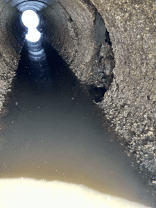
The interior of the culvert on Mattapoisett Neck Road shows evidence of deterioration. (Photo courtesy town of Mattapoisett)
The coastal town of Mattapoisett is embarking on a multi-year culvert replacement project after receiving a $3.5 million federal grant from the National Oceanic and Atmospheric Administration.
The culvert on Mattapoisett Neck Road is within a large salt marsh in the upper part of Mattapoisett Harbor, near the mouth of the Mattapoisett River. The marsh is one of the largest contiguous systems in Buzzard’s Bay.
The marsh has been losing vegetation for years now, according to Town Administrator Michael Lorenco, because of the undersized and deteriorating culvert. The deterioration is also jeopardizing the roadway, which is the only way in and out for about 250 homes. The culvert in question, between Molly’s Cove and the Mattapoisett Neck salt marsh system, is one of three in the area.
“For any coastal community, marsh land is important,” Lorenco said. “It provides a buffer for storm events, sea level rise, as well as a habitat for wildlife and other things.”
Town officials first heard from local groups more than six years ago that the marsh was compromised and that the culvert was the suspected culprit. That suspicion was confirmed by a study completed in 2024.
The undersized culvert prevents proper flushing of the marsh during high tide, which traps salt, and is completely underwater during high tide, which is both damaging to the marsh environment as well as the physical structure.
Using a number of small state grants, the town partnered with Mattapoisett Land Trust, Buzzards Bay Coalition and Buzzards Bay National Estuary Program to do preliminary research and analysis on tidal impacts on Molly’s Cove, the culvert and the roadway to determine what would need to be done. The partnership has continued through the federal grant process.
“That set us up for the grant application with the Massachusetts Office of Coastal Zone Management, because we had enough facts to show that there’s some hydrologic concerns that could be impacting the marshlands,” Lorenco said.
He said state staff worked with the town and its partners for several months to help draft the competitive grant application. The project was particularly appealing because multiple groups were working together.
“I think when you have everybody on the same page, just at that base level, it makes it very easy to kind of push a project forward,” Lorenco said. “I’m not a scientist — that’s not what the town’s job is — but partnering with people who are, who are good in that area, this whole group who have experience dealing with these issues, obviously the process is much easier.”
The town is now working on the survey, design and permitting phase of the project — a process expected to conclude in the summer of 2027, with construction beginning that September. The longer timeline for the project is due to tidal changes impacting when work can be completed, and needing to maintain access to the road for area residents, Lorenco noted.
He said state help was vital in the cumbersome application process for the reimbursement grant.
“None of this would have been possible without the Office of Coastal Zone Management and their team, and the Municipal Vulnerability Preparedness program,” Lorenco said. “We had gone through a couple rounds of grants to lead us up to this big application. Without their assistance, we wouldn’t be in the position that we are today.”