Who is a member?
Our members are the local governments of Massachusetts and their elected and appointed leadership.
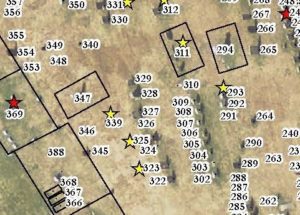
A portion of a map shows where veterans are buried in one of Chicopee’s cemeteries. Yellow stars signify veterans of the Revolutionary War, while red stars reflect Civil War service.
Hoping to keep alive the memory of its departed veterans, the city of Chicopee has been digitally mapping service members’ cemetery graves and plans to build interactive online maps for public use.
For more than two years, the city’s Veterans Services Department and geographic information system coordinator have been creating digital maps of Chicopee’s 11 public and private cemeteries. When they’re finished, they hope to have color-coded maps identifying the names, dates of death, conflicts served, and exact final resting spots for more than 7,500 veterans, including those who served as far back as the Revolutionary War and the War of 1812.
“Not only does this help us remember, it provides a link to the past service and an ongoing commitment to those who may serve in the future,” said Mayor John Vieau. “They will not be forgotten.”
Officials said Chicopee had lacked a cohesive way to track veterans’ graves, and military families were calling the city, asking why loved ones’ graves lacked flags for Memorial Day, which is required as part of the city’s veteran responsibilities.
“This bothered not only those families and veterans, but all of us,” Vieau said.
For years, volunteers walked the cemeteries before Memorial Day and placed flags on graves indicating military service, said Stephanie Shaw, the city’s veterans services director. But not all veterans’ graves bear military markers, and some older headstones are hard to read, officials said. In addition, Shaw said her staff had identified gaps in communication with cemetery owners over plot management, and started updating and correcting their database.
Meanwhile, Michelle Santerre, Chicopee’s GIS coordinator, had already been working with the Parks and Recreation Department, which oversees the city’s public cemeteries, to convert paper records into digital files. Shaw asked Santerre if she could also fold the veterans’ grave mapping into her efforts.
“I didn’t even get the sentence out, and she said, ‘Yes, we can do that,’” Shaw said.
To create the maps, Santerre took Google cemetery images and overlaid the city’s maps, often old and hand-drawn, to mark the plots. Santerre also read headstones at the cemeteries to match up the mapping.
“It’s a puzzle, so there’s some amount of field work to really get you started,” Santerre said, “but then once I was able to find a starting location to make sense of some of these old historic maps that we had, I was able to map out the majority of even the private cemeteries.”
At this point, Santerre said, she has run out of city records to feed into the digital maps. Next, she will ask the private cemeteries for their more recent records to keep going.
Volunteers can now use printed maps for placing Memorial Day flags, and Shaw said the maps will also help with wreath placement in December. Shaw plans to give Santerre updates each May, with additional information received from families, a state military database and other sources.
So far, the project hasn’t cost Chicopee additional money because it has relied on staff time and existing software, though Shaw said she may investigate grants to help subsidize future work.
Shaw said Chicopee has greatly improved its Memorial Day flagging since undertaking the digitization project. Eventually, the city also plans to launch interactive, online maps so people can look up veterans’ gravesites by name, conflict or military branch.
The city is already better able to help people locate veterans’ final resting places.
“I can tell them the plot number, I can tell them the section or the row,” Shaw said. “We can make sure that future generations know how to find them, and that’s really important, too.”