Who is a member?
Our members are the local governments of Massachusetts and their elected and appointed leadership.
MMA Innovation Award winner, From The Beacon, February 2022
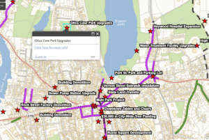
People can find out more about building projects in Gardner by clicking on various locations on the city’s online map.
To keep residents better informed about local development, the city of Gardner has built an online, interactive map to help people understand what’s going on with that hole being dug in one part of the city, or with those steel beams going up in another.
Launched in August 2021, the map allows people to click on starred locations around the city and pull up information about timelines, costs and funding sources for various projects. The city said it wanted to create more transparency around both public and private-sector projects that are working their way through the city approval process.
Mayor Michael Nicholson said the map answers questions residents typically have when they notice a building project in the city, such as: what’s the timeline, what will it look like, how much does it cost and who’s paying for it? He said residents also ask why the city isn’t doing something about a particular site, even when it is. By capitalizing on resources it already had, he said, Gardner was able to improve public awareness around all project sites.
“It’s all existing software and staff that we already had available to us,” Nicolson said. “So it’s costing us nothing, but it’s getting all of the information out to the public in ways that we couldn’t do before.”
Nicholson said he had asked his team to identify the most frequently asked development questions, so they could put the answers to those questions in one place. City departments spent about two months on the map, gathering information about the active projects, and compiling financial data, planning process information and other details about the projects. The city’s geographic information systems coordinator plotted the projects on the map and loaded the background information for each project.
City Engineer Chris Coughlin said the biggest challenge was compiling the information and building the initial map. It has been easier to maintain the map in the months since, he said.
“The map is being updated as quickly as new projects are starting,” Coughlin said. “The effort required to add additional projects is quite low.”
To keep the website from getting too cluttered, Gardner’s map focuses only on projects that have experienced some sort of activity within the past year. But the city is hoping to enable the map to store and display historical data as the effort extends into the future, Nicholson said. The idea would involve having layers of data that could be selected for different years, he said.
In the meantime, the map has achieved Gardner’s goal of answering development questions more efficiently, Nicholson said, and the city has gotten positive feedback about it. City Hall is now getting fewer inquiries about projects, and the people who do reach out with questions now tend to have better information before making the call. In response, city officials can point callers to concrete information online, he said.
“It puts people at ease to see it in writing, too,” Nicolson said. “They can call us at City Hall, and we can tell them the answers to their questions, but to see it published in a public forum like that also does help just alleviate any concerns that they may have.”
For more information, contact GIS Coordinator Jon Fiore at [email protected].